Duisburg-Nord Landschaftspark – V: Night illumination
Reply
Relics present documentation with the frame at the scale of the industrial plant. Each of these objects represents one stage in the process of producing steel, from the foundry to the furnace to the logistics of ore. They are the icons of the park, and present an almost charicature of their former roles. Simultaneously, they also embody the sheer scale of the undertakings at Duisburg Nord.
Passages presents a brief selection of the variety of circulation corridors present in the park–both original and interventional.
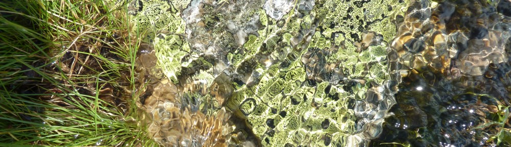
Fragments present a case of variable logic, based on a process of framing, among others. Some fragments are typically curatorial and include very minute details stripped from the larger context. Others present larger portions of differing objects, sometimes collaging context or eliminating it completely. Fragments attempt to re-present the overall gestalt of their context by presenting only the essential.
Fragments – large and small:
Duisburg-Nord Landschaftspark is a post-industrial reclamation project on 180 hectares, located in the industrial belt of the Rurh Valley, in Northern Germany, outside Dusseldorf. Latz and Partners began the design work around 1990, after residents prevented the raizing of the steel mill after it shut down in 1985. As the facility had been abandoned for sometime before any plans could be implemented, nature had already began taking back the park. Latz’s design combines preservation architecture, reclamation, and incidental phytoremediation alongside assorted landscape tropes. The park permits a new mode of inhabitation of a once brutal landscape and infrastructure.
Latz’s design included many low-impact design strategies: hazardous conditions were either remediated (such as the stripping of accessible electrical fixtures) or cordoned off; the existing successional growth was documented and allowed to proceed; architectural features were adapted to new uses, which included renovation and demolition; demolition of selected architectural constructs permitted their foundations to join the landscape matirx; procession through the industrial relics was choreographed to permit access to certain objects; new walkways were combined with existing circulation to create a woven route through the site; selected cells within the foundry were planted in the style of a classical landscape in rhetorical configurations; and many objects were modified or repurposed for new programs, such as a garden, a climbing gym, or a slide that echoes the extensive steel duct work that characterizes the site; existing growth was augmented with additional plantings, such as betula pendula and other plants that colonize disturbed sites.
Documenting such an enormous site is quite challenging, but after reviewing both sketchs and photos, several categories emerge: botanicals; context; fragments; passages; and relics; each having their own sense of scale and framing–both temporal and spatial. The botanical category focuses on some of the minute details of singular vegetative growth within the park. Context depicts the surrounding area. Fragments present portions of the park that convey the gestalt of the whole. Passages address the syntax of circulation, both new and adapted. And relics documents the large industrial assemblage that constitutes the core identity of the park, its history, and its iconography.
Context:
Tanumeshede is the site of hundreds of bronze-age rock carvings, dating back to 1700-500 BC, and located at what was once the sea shore. But due to the glacial uplift here, it is now located 3 miles inland from the North Sea. The Vitlycke Museum serves as the curatorial and research base for the park, which is a world heritage site.
After a night out in Göteborg with Resilience Center friends, it was suggested that I check out the museum on my way up the coast. It couldn’t have been a better suggestion on a foggy late afternoon. Regarding the carvings, there is an implicit geographical/ cosmological shift embedded within the site of the carvings: fresh water springs emerge at the top of the rocks on which the carvings were made, even quite long after a rain shower ends. This water cascades gently down the rock faces, integrating the carvings into a much larger set of tapestries. The Scots-pine needles and birch leaves that cover the rocks are an additional component, but are cleared away from the immediate area of individual carvings by museum staff.
Skogskyrkogården, or Woodland Cemetery, is Sweden’s most famous cemetery, and known world-wide for its articulation of landscape and integration of architecture into that topography. Beginning with Gunnar Asplund and Sigurd Lewerentz’s winning competition entry in 1915, the City of Stockholm began development of a modern, non-denominational cemetery that employed cremation as the main form of burial, maximizing available space and minimizing headstone sizes. The gravesites are worked into an existing and developing forest landscape, several km south of Stockholm, consisting of Pinus sylvestris, Acer platanoides, Betula pendula as well as several variants of Picea abies. The cemetery is a project of subtle and severe contrasts, not least the dried golden birch leaves that spiral downward in the wind, sunlit against the dark backdrop of spruce.
The 250 acre cemetery contains more than 90,000 graves to date. It is separated from the surrounding land by a 2-foot thick dry-stacked stone wall, and veiled by birches and pines that grow along the perimeter.

Dry-stack perimeter wall
The perimeter wall folds inward at the main entry,  to create a 50m sub-grade threshold. The stonework here is more precise, with mortared joints and honed faces. A small water feature reveals the subterranean aspect of the threshold. The entry aligns with the main axis of the cemetery, revealing the famous cross, its gently sloping pathway, and the crematorium to the east (left):

 Though containing some formal elements, such as the above axis, which is echoed throughout the cemetery, though often in dissipation (as in the hill, above), the grounds are quite asymmetrical, and provide for both classical notions of prospect and refuge within its formal and informal elements.

Memorial Grove


Angel of Death (Carl Milles) Main Entry Axis, Woodland Chapel


Grave Plots

Grave Plots
 The overall informal design of the cemetery allows for cyclical processions in and out of the chapels that an overall formal design might discourage. One enters the chapel on one axis, and upon exiting the same door, turns to the side to align with a new axis, reorienting oneself to a certain territory, gravesite, or garden.

Lateral-Axis, Woodland Chapel
This strategy permits for a spatiality of mourning, a sequence of semi-choreographed (but open-ended) processions, and a horizon gently folded into the forest.
Stora Karlsö is a one mile by one mile windswept island situated four miles off the west coast of Gotland, which, in turn, is located approximately half-way between Sweden and Latvia, one hundred miles south of Stockholm. It rises 170 feet (52m) out of the sea with steep limestone cliffs, with a delicate, alvarian biotope ontop. Jeff Ranara, my adviser here, was thoughtful enough to place me on the list for the first ever all-staff trip of the Stockholm Resilience Center, all expenses paid.
The goal of the trip was to allow staff to decompress, develop new relationships, and discuss the success and future progression of the Center. The trip was coordinated by Olof Olsson, deputy director of the Stockholm Resilience Center, in conjunction with Henrik Österblom, Jonas Hentati Sundberg, and Martina Kadin, who have been working on the Baltic Sea Bird study on Stora Karlsö. We were treated to amazing scenery, delicious food, and even live music by Jonas and one of the park rangers, who grew up on Gotland together.
The sea bird study was started by Olof Olsson in 1997, one of the first studies of pelagic birds in the Baltic, it sought to use the birds as an indicator species for the Baltic ecosystem. One exceptional development in the study was the construction of a 4-story bird-nesting shelter, grafted to the cliff side, that allows researchers to access roosting mures throughout their lifespan. This is achieved by providing man-made nesting ledges on the outside of the structure which are accessed via small doors from the inside of the structure. Birds can be banded, weighed, and counted year after year.
 The survey house is accessed from the top of the cliff, near the lighthouse, and descends several stories before the survey levels are reached. The island provides refuge for countless sea birds as well as other species, and typically the majority of beaches are closed to foot traffic in order to protect the nesting sites. Fortunately, by early September, these sites are opened, and we had unrestricted access to the entire island.
The preservation plan that protects Stora Karlsö was started by Willy Wöhler, in 1880. He convinced many well-to-do Swedes of the natural value of the island, and began restoration work shortly thereafter. Interestingly, with the removal of the substantial sheep flocks, the ecosystem did not return to its native balance, but quickly became overgrown with Juniperus vegetation. This called for a managed re-introduction of some sheep in order to curb the developing monoculture. Today sheep continue to graze the island, albeit in limited numbers (approximately 300-500 per season).
One remarkable tree, sited in the ruins of an old burial mound is known as the Linnaeus Ash, a specimen of the species Fraxinus excelsior. It served as a navigational aid for many years, and has been reinforced with concrete from time to time, as was common practice in with older trees Sweden for quite some time.
 The flora of Stora Karlsö is noteworthy for several rare wildflowers, its stark alvar environment, and for evidence of neolithic inhabitation. Besides the numerous burial mounds, excavations have also revealed numerous bronze-age implements and other acheological evidence of continued inhabitation, that continues into the present under the preservation management system.
